
Saddle Mountain 8424′ and Marion Point 6480′
Total Time: 8 hours
Roundtrip Mileage: 12.0
Elevation Gain: 6,050′
Crux: Class 3
Trailhead: Saddle Mountain Trail, no services


Saddle Mountain along the eastern edge of the North Rim, has the esoteric distinction of being the highest summit INSIDE of the canyon. Named for it’s saddle-like profile when viewed from the north or south, Saddle Mountain towers over the infamous Nankoweap Trail, well regarded as the most difficult named trail in the Grand Canyon. The trail was originally a Native American route to the river, improved upon by John Wesley Powell and crew in the 1880s. In fact it is believed that Powell made the first recorded ascent of Saddle Mountain, and is one of the first major mountains in the Grand Canyon to be climbed. I had wanted to climb Saddle Mountain for years, serving as a backdrop in the Eastern Grand Canyon and visible from many of the various summits I had climbed to date. When I finally had a chance to get to the north rim for only the second time since moving to Arizona, Saddle Mountain was the first summit on my list. Although certainly a worthy summit in its’ own right, I hoped to combine it with Marion Point further down the Nankoweap Trail to make for a very full, two summit day. I left for the north rim straight from work and slept over night off one of the various dirt roads along Kaibab Plateau. The next morning I finished the drive and reached the Saddle Mountain Trailhead at around 6AM, some lingering clouds hanging from the rain the night before. The Nankoweap Trail actually doesn’t formally start until reaching the saddle between Saddle Mountain and the rim, with the first section of trail, the Saddle Mountain Trail, intersecting a second approach trail from Rock House Valley, used in the winter months when the Kaibab Plateau is snowed in. After a short drop, the trail ascended Point 8881′, which is the highest point directly on the canyon rim (the high point of the entire Kaibab plateau is nearby and about 400′ higher).

Unlike the other maintained trails into the canyon, this one was a bit more overgrown, with a decent amount of acacia spilling onto the trail. The route wove over a few false summits, then descended northern brushy slopes several miles to the saddle and start of the Nankoweap Trail. I had originally intended on climbing Marion Point first, dropping deeper into the canyon earlier in the day when it was cooler. But the questionable weather made me think I should go for the much higher Saddle Mountain first, and I followed faint game trails from the saddle to the western Coconino buttress spilling off the summit ridgeline.


I was able to avoid the fin of sandstone by contouring to the north up brushy talus slopes. There really weren’t any clean lines up, but it was thankfully mostly small oak trees and grass with very little cat claw. I reached a small notch in the Coconino and a short class 2 break brought me to the summit ridgeline above the Coconino cliffs.


The summit was still a bit farther east, and I continued along the summit ridgeline over larger and larger false summits. The vegetation, although still present, was relatively sparse on the ridgeline and largely avoidable. The grade improved on the last stretch to the summit, and I reached the large summit cairn in the center of the broad summit only about 2 hours from starting out. A summit register was stuffed in an old Parmesan cheese container (my kind of peakbaggers) and was actually a bit less full than I expected- the register went back to 1991 and there were occasional gaps of 3-4 years between entries. Given that this was one of the easiest summits on the North Rim (at least in my experience), I found the lack of entries really surprising. I did note that Sean Peters entry remarked that it was his first Grand Canyon summit, a name I had seen in every summit register and someone who is now closing in on nearly 100 peaks in the canyon.


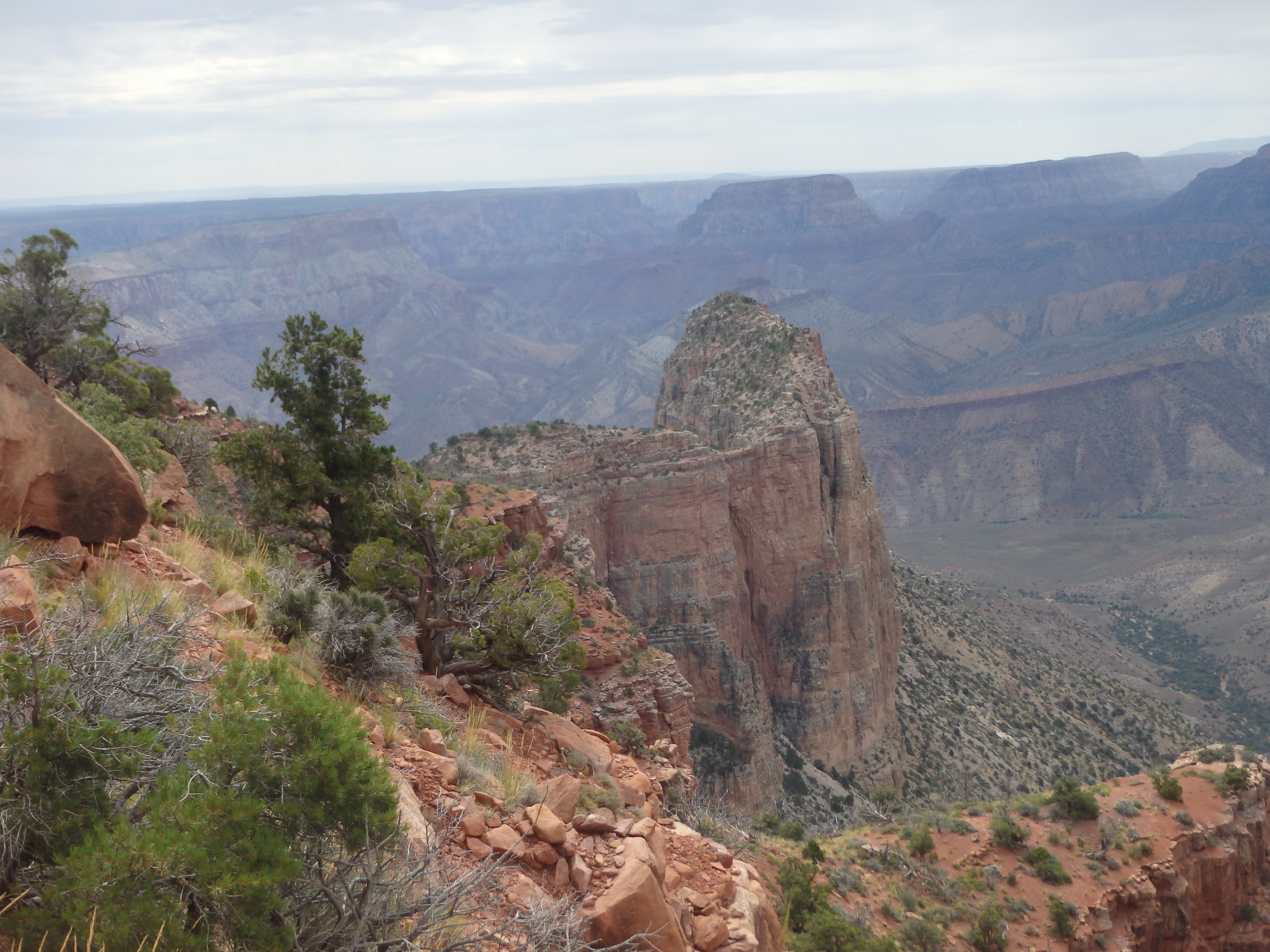
With a full day still ahead, I headed cross country off the summit and down the ridgeline. The decent down the brushy north slopes through the Coconino was uneventful, and I was back at the Nankoweap Trail in no time. From the saddle, the Nankoweap Trail switchbacked down several hundred feet before leveling off along a band of Supai. The trail held more or less steady at this elevation for several miles, contouring west on shelves at most a few feet wide just above 100′ cliffs. As I contoured around I had my first look at Marion Point, a huge fin of Redwall Limestone jutting out of the south slopes of Saddle Mountain.


It looked very far, and more difficult than I was expecting. But the weather was actually improving, and this section of trail was easy, being more or less level. Moving quickly across the long traverse, I reached the Marion Point campsite sitting over the summit at around 10:30AM.
The campsite was small, and situated underneath a row of 4 small sandstone spires standing 30-40′ along Marion’s connecting ridgeline. I cached some extra water at the camp for the return trip, then dropped onto the Supai slopes to the west (right) of the rock spires with an easy class 3 stem between a couple large boulders. The Supai talus was packed from the recent rains, so I did my best to keep to the ridgeline where it was a bit less steep. As the ridgeline descended towards Marion Point, there were a series of short cliff bands, usually never more than 5-6′, which could all be easily managed with one of many class 2 weaknesses. As I neared the low point between Marion Point and the connecting ridgeline, I was surprised to see how deep the notch was. A steep class 3 gully dropped 20′ to the narrow saddle, and the rock changed from soft Supai sandstone to the sharp Redwall Limestone.


A bit more class 3 brought me up from the low saddle to the first false summit on the ridgeline. This dropped to a narrow isthmus only several feet wide, the quickly climbed the remaining distance to the narrow summit.


The exposure to the west was dramatic: limestone cliffs 1000′ straight down. It was difficult to tell the true highpoint (it definitely isn’t the first one after the isthmus), so I continued along the ridgeline until I was sure I had tagged it. There was a summit cairn at what appeared to be the highpoint, and I left a summit register tucked into the rocks. When it was time for the summit photos, I turned around to face north for literally the first time since Saddle Mountain, and was surprised and somewhat alarmed to see a huge thunderhead directly over Saddle Mountain.


There was little coverage along the route to the summit from Nankoweap Trail, and I was not looking forward to scrambling wet sandstone. So my time on the summit was short lived as I dropped north along Marion Point’s summit ridge back to the deep class 3 notch. I had made it about halfway back to the trail when a light rain started, and to just below the spires near camp when the rain increased and the thunder rolled in. The upside of the Nankoweap Trail is that it closely hugs Supai cliffs with multiple caves, being less exposed to lightning compared to most other Grand Canyon trails. The downside was several of the very narrow sections would be particularly sketchy when wet.

Once the first wave of rain had passed, I left Marion Camp and headed back up the Nankoweap Trail, wet in spots but not enough to be muddy or slick. I was nearly to the switchback when I nearly stepped on a rattlesnake trying to warm itself in the sun, the second rattler I had seen in the canyon. It gave me a not so friendly rattle to back off, and I danced around the brushy slopes above it in order to press on.

Once back at the saddle between the rim and Saddle Mountain, I had my first good luck at the weather. The storms were mostly to the north in House Rock Valley, and I dropped my pace thinking I was in the clear. I ascended the brushy slopes back up towards the rim and even took a break under some trees thinking the storm was moving off to the north. But as I climbed higher, I had a look at another storm system sitting right on the rim.

Just as I was reaching an exposed, tree-less section, a bolt hit the rim, at most a few miles away and very near to the trailhead. It was time to kick it back into high gear… I half jogged the remaining distance to the trailhead and made it to my car just as another round of rain hit. Although I had planned to climb Tritle with any daylight I had left, I abandoned this plan given the unsettled weather and headed to the North Rim lodge for an IPA and BBQ brisket.