
Wilson Peak 14,017′ and Gladstone Peak 13,919′
Total Time: 13 hours
Roundtrip Mileage: 11.1
Elevation Gain: 5250′
Crux: Class 3
Trailhead: Rock of Age Trail


The San Juans of Colorado feature over a dozen summits over 14,000′, including 3 summits in the Wilson Group, which some argue are some of the most difficult 14ers in the entire state. Mount Wilson and El Diente are class IV by their easiest route, and the volcanic San Juans are notorious for their loose and rotten rock. Wilson Peak,the easiest of the group with a short class III scramble at the top, is most famous for being the mountain that inspired the Coors logo, with a dramatic north face and well shaped pyramidal summit. I had planned a multi-day stint in the San Juans, my first time to the area, and decided to start with Wilson Peak, mostly because it was one of the closer 14ers in terms of drive time to Phoenix. I left work and drove 7 hours towards Telluride, losing an hour due to the time change, and falling asleep in the back of my car at the start of the dirt road to the trailhead at 2AM. I grabbed a few hours sleep with my alarm waking me at 5AM, and groggily drove the remaining 8 miles of dirt road with an energy drink trying to find the motivation to move a little faster at the early hour.

There were several other groups at the trailhead when I arrived, and after organizing my gear, I set out on the Rock of Ages trail shortly after 6AM. The trail is predominantly in the trees for the start, and in fact is one valley west of Silver Pick Basin and the Rock of Ages saddle. The trail switches over Elk Creek, then circuitously crosses the ridge higher up to avoid some mining claims lower down Silver Pick Basin. I hit treeline shortly after crossing into Silver Pick Basin, and although I was still in the shade, I would be exposed the remainder of the day.

I followed the trail through the loose talus over several small lingering snow patches, steps well kicked in from numerous other climbers this season. The longest snow patch was just below the saddle and I took my first break past the snow, my first time viewing Mount Wilson, El Diente, and the intermediate 13er, Gladstone Peak. The north facing slopes of Mount Wilson and El Diente still had quite a bit of snow, although I planned to climbed them from the south when that day finally comes.


After chasing off a bold marmot, I continued along the trail, now a thin use trail, as it crossed over the northern ridge of Gladstone Peak to traverse across Wilson Peak’s south slopes. While a trail could still be followed, this section was a little closer to class II with some loose ledges and a bit of route finding, but nothing difficult.

I decided to cut the route and head up more directly to the ridgeline to look into Silver Pick Basin below. There was a similar use trail closer to the crest that I followed along and ultimately brought me to the base of the false summit. I foolishly headed directly up the false summit with loose rock, only to a use trail skirted around to the north side. On the north side of the false summit I had a good look at the remainder of the climb and the crux, about 100′ of class III up a narrow gully.
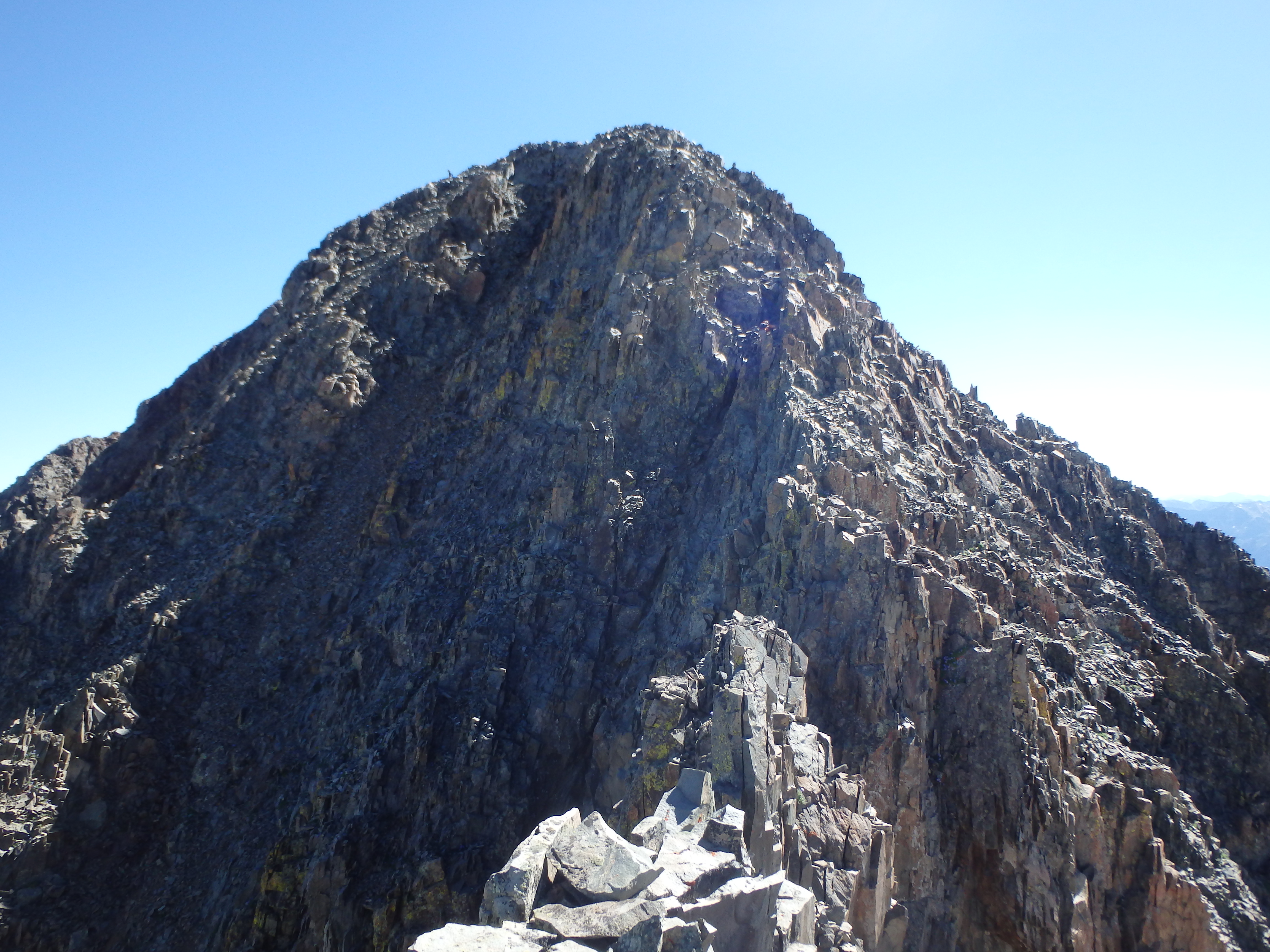
There was a climber headed up as I descended to the notch, and once he neared the summit, I headed up myself. The climbing wasn’t bad at all, and if it wasn’t for all the loose rock in the range and the very long approach, I would recommend this as a good starter class III 14er for people. I included a first person video of the crux scramble:
There were a few others at the summit after topping out at 10AM, about 4 hours from the start. I took a nice long break at the summit, and enjoyed my first Colorado 14er in over 2 years.


The weather was still looking perfect, and I started eyeing Gladstone Peak in the distance. The north ridge was a fractured mess, and I had read that it was loose. But it looked very close, probably only a 1.5 mile detour each way, maybe adding 2-3 hours on to my day at most. With such beautiful weather, how could I resist? I hiked back down the loose slopes to the start of Gladstone’s north ridge, passing several other climbers along the way. I stopped to chat with one who had been up Gladstone before and offered this advice: “Very doable, but very, very loose. Stay close to the ridgeline.” I kept this in mind as I started along the jagged ridge, often being forced off the ridgecrest to the east with occasional loose sections of class IV. The climbing was tedious and very slow, and after an hour I was only halfway along the ridge and definitely getting tired. At the low point of the ridge I decided I would waste too much time try to reverse the climb along the ridge, and I would be better off dropping to the east into Navajo Basin. I cached my trekking pole here to better use my hands and continued along.

After at least 6 false summits, the ridge finally started to head more directly towards the summit. I continued to try and keep to the ridge crest, but staying true often made the moves class IV, and I tried to remain conservative along the NE slopes. After 2 hours on the ridgeline, I was only about 50′ below the summit, but was well off the ridgeline headed up loose steep slopes.

As I hopped onto a large rock, the entire slab started to slide down the mountain with me standing on top. It turns out when you try to jump off a moving object while you yourself are also in motion, your brain is incapable of precise calculations on how to get yourself safely onto something a bit more stationary. As I jumped from the sliding rock (with a lot of vulgarity in mid-air) I completely botched the landing, and dropped onto a narrow rock ledge, landing with my full weight on a fully inverted and partially flexed (rolled) left ankle. I heard a small ‘pop,’ and dropped onto my side with even more cursing. Although I did not hit my head, I was wearing a helmet at the time. I didn’t dare take off my shoe to examine my foot, as if it became swollen quickly, I would never be able to get my shoe back on. I took a big dose of ibuprofen and started trying to feel exactly where I was tender. The ankle seemed okay, with most of my pain at the base of my fifth metatarsal. I stood up to test how weight bearing would go: success, albeit painfully. The pain was intense overall, but didn’t really worsen with standing. I looked up at the summit, then back to Rock of Ages Saddle. My day of a successful and uneventful tag of a 14er had just turned into an unpleasant epic by getting greedy with a nearby bonus peak. My pain was replaced by mostly rage. Angry and determined, I slowly hobbled up the last 50′ to the summit and collapsed at the top. Looking back down the ridge, I felt pure dread at how slow I would be moving. I threw my headlamp in my pack almost as a joke, thinking it impossible that I would need it after a 6AM start.

I worked slowly down the ridge, this time sticking to the true ridge and solid rock more judiciously, even if it meant some extra elevation gain over the various false summits. While the ibuprofen was beginning to kick in, the unstable rock and subtle movements made the descent incredibly slow and painful, and it took another 1.5 hours to get to the low point where I had cached my pole, which I was desperately looking forward to using as a crutch.
But the pole was gone. There was no one else on the ridgeline all day, so it seemed unlikely that someone took it. I guessed that a hungry marmot probably thought the straps looked appetizing, and dragged it off the mountain. But if anyone finds a black and orange Leki pole along Gladstone’s north ridge, I’ll gladly pay the shipping to get it back…
I continued along the ridge, thinking maybe I had cached it at a different low point, and after a few more false summits, I determined it would be faster to just continue back to the use trail to Wilson Peak rather then drop into Navajo Basin. It was a small victory when I eventually reached the use trail again, having spent 6 hours on the 1.5 mile ridgeline thanks to my injury, 4 hours of that on the descent. While my pace improved on the more stable ground, there was still a good amount of talus across the trail to deal with, and I did not have a trekking pole to keep myself steady. The snow was starting to refreeze in the late afternoon shadows, and I had to move across cautiously. Once out of Silver Pick Basin, the trail was became more packed dirt then loose rock, and my pace improved further, driven solely by the prospect of a cold beer and something greasy to eat. It was about 7PM when I reached the car, a 13 hour day, with 6 of the hours dealing with Gladstone Peak, it’s loose and rotten north ridge, and my very injured ankle/foot. While in retrospect I have certainly been on looser routes, including some routes in the Sierras, you can’t always account for some bad luck even on the most solid rock. I would later find out that while no bones were broken, I had torn my ATFL. But for the time being, I high tailed it into Telluride for some well deserved beers and a hot greasy Calzone to ease my pain….
