
Mount Davis 12,303′
Total Time: 2 days (backpack)
Elevation Gain: ~8,000′
Roundtrip Mileage: 30.4
Crux: Class 2-3
Trailhead: Rush Creek, full services
Companions: Holly


Mount Davis is a 12K summit in the Ansel Adams Wilderness near the southeastern border of Yosemite. Serving as a backdrop for the Sierra’s famous Thousand Island Lake, the summit is largely overshadowed by the taller and more dramatic Mounts Banner and Ritter to the south, and Mount Rogers and Lyell to the north. But the proximity of these nearby summits to Davis is what makes it so special, with a unique angle of the Ritter-Banner Saddle, as well as views reaching into the heart of Yosemite’s remote high country. After being away from the Sierra’s for over a year, I had convinced my wife to backpack to Thousand Island Lakes, with a plan to tag Mount Davis in the morning before hiking out. Despite being Labor Day Weekend, we were able to score a walk-up permit for the lake via Rush Creek, and started up the trail mid morning, the early September sun beaming down on the exposed trail. It was my first time hiking the Rush Creek Trail, and despite the sun exposure, I enjoyed the views of Carson Peak straight ahead and Silver Lake down below. The trail slowly ascend over about 1.5 miles to the switchbacks below Agnew Lake and the grade increased as we worked our way above the lake outlet and dam.
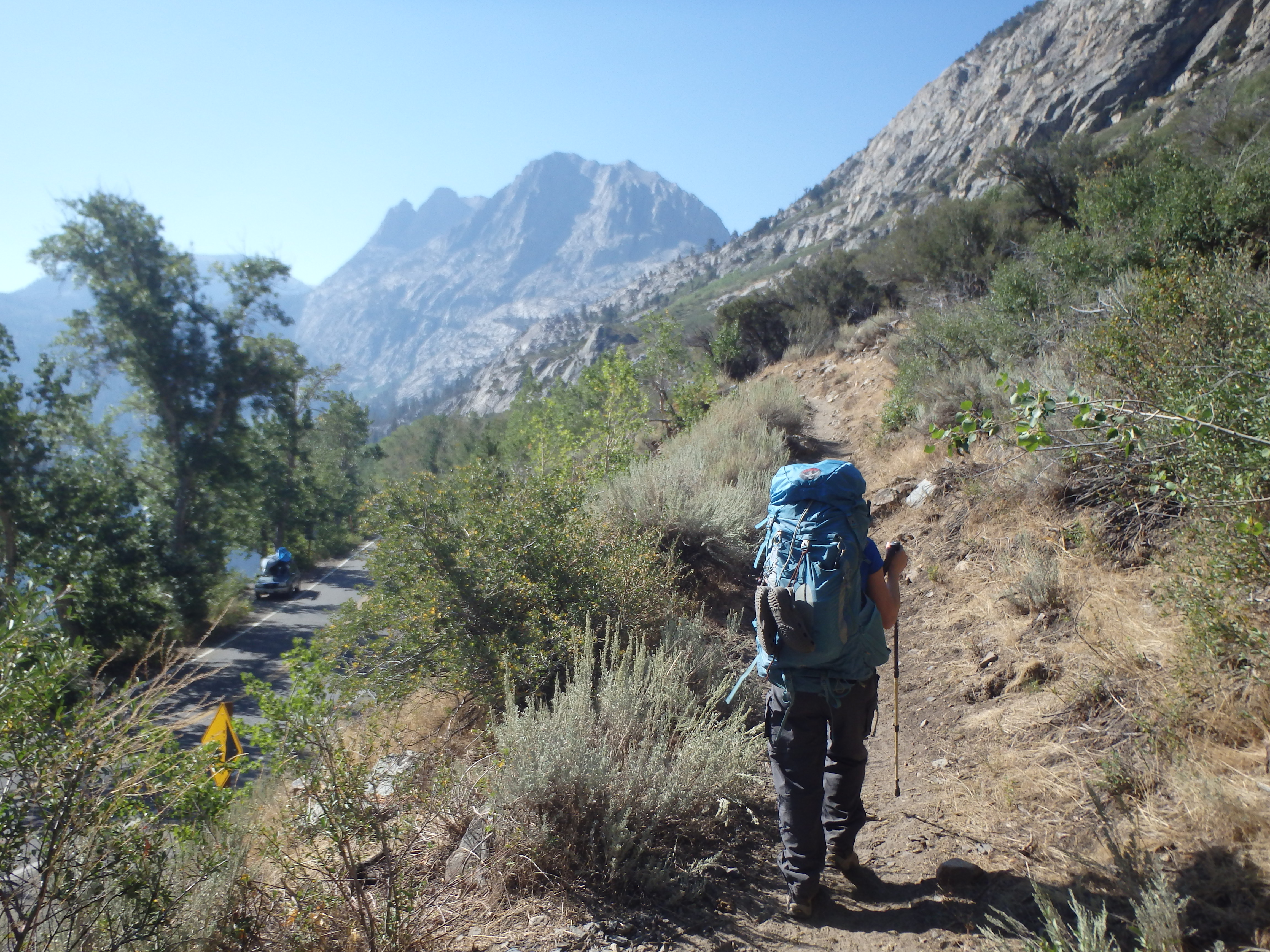

Agnew Lake is the first of several artificial dammed lakes west of June Lake. The above average snowpack of the 2016-2017 winter had called into question the integrity of many of these dams, and there was active construction and repair on the Agnew Lake dam, the hum of equipment detracting from the wilderness experience we were looking for. Unfortunately, the construction also meant that any trails that cross below the dams were effectively closed, including the Spooky Meadow Trail. This ultimately meant an extra 2 miles each way to Thousand Island Lake for two un-acclimatized hikers that hadn’t backpacked in over a year.


I had planned on filling up water at Agnew Lake, but was surprised to find the water level quite low for the dam construction, and refilling would have required a scramble down scree to the water below. So after a short break, we continued along to Gem Lake, the second dammed lake along the trail, less than a mile farther. Gem Lake was much more picturesque, with trees lining the lake shore and some of the higher peaks to the west popping into view.


Although this dam was not under construction, the water level was still quite low, and we had to hike another mile to Crest Creek and the trail junction to Gem Pass before we could fill our waters for the first time all day. This section of trail was really the first area of consistent shade all day, and we took advantage by soaking our feet in the cold stream and having a late lunch.


The trail continued by hooking south and cut away from Gem Lake, slowing climbing uphill before dropping to the outlet of Rush Creek.

At this point we were about halfway to Thousand Island Lake and were definitely feeling the altitude. The trail ascended steeply towards Clark Lakes, and our pace dropped considerably as climbed to nearly 10,000′. From Rush Creek, it took over an hour to reach Clark Lakes, with a bit over 2 miles to reach Thousand Islands. A number of other groups that were hiking along the Rush Creek Trail had decided to camp at Clark Lakes for the night with the extra mileage from the closure of Spooky Meadows.

But with the majority of the elevation gain behind us, we took a short break and continued up and over Agnew Pass, giving of our first look at the dramatic North face of Mount Banner. The trail dropped about 200′ to a junction with the PCT for regaining the elevation, bringing us to the outlet of Thousand Island Lake.


Of the dozens of lakes I’ve been to in the Sierras, this one takes it. The lake was spotted with small boulders and tiny namesake islands, and framed by the dramatic north face of Banner and east face of Davis. A ranger at the outlet checked our permits, and we hiked the lakeshore another quarter mile to a beautiful spot for the night. There were a number of other groups scattered around the shoreline, but the boulders provided some privacy and we made dinner and watched the sun set behind Banner before heading in for the night.


The route up Davis swung on to west facing slopes, and even with the warming temperatures from the rising sun, the snow was still off limits with a rock hard crust over the top. So I continued to scramble above the snow, finding plenty of viable options that avoided the ice and kept me off anything too loose. Although Davis has been described as a bit of a talus slog, most of the rock was pretty solid, and I was able to hop boulder to boulder at a pretty good pace. I angled up towards a notch to the summit plateau and breached the summit ridgeline with the sun now shining brilliantly over Thousand Island Lake below.


The appearance of the ridgeline on the map was a bit deceptive, with a number of false summits and a shallow, snow filled basin just below that I needed to continue to avoid. Traversing beneath the false summits was a bit looser and more tedious than earlier in the route, but I was soon pushing up the final slope to the summit. The views from the top were outstanding. Mount Ritter and Mount Banner dominated the view to the south, with sun reflecting off their glaciers. To the east was Thousand Island Lake among the various other lakes east of the Sierra Crest. Immediately to the north and north-west were some of the most remote summits in Yosemite National Park including Lyell, Rodgers and Electra. Although there were a number of fires to the west, I could pick out parts of the Clark Range and even some of the higher summits in the western Sierras near Shaver Lake.


It was about 7:30 AM, taking about 3.5 hours from camp, a good deal of it wasted scrambling over the snow. I had told Holly I would try to be back by 9AM, and if I had any chance of meeting that goal I needed to descend. I looked for a shortcut down the east face but found only icy cliffs and continued back the way I came. At the notch that brought me onto the summit plateau, I stayed a bit more to the west, utilizing a series of solid granite ledges and slabs that I could work down quickly with decent traction. Although there was a run of snow separating me from Glacier Pass, there was a small section that had melted out which I was able to cross. A bit more inefficient scrambling brought me back to the pass 35 minutes from the summit, but still with a long way back to camp. I started working down the talus again, initially avoiding the upper patches of snow. The drainage was west facing and had already had 2 hours of solid sunlight to soften it. So I tentatively stepped onto the snow and was pleased to find it the perfect consistency to boot ski down, just soft enough to keep me from sliding uncontrollably down to the rocks below. A number of groups were on their way up for the day, most headed for either Mount Ritter or Mount Banner.


Reaching the bottom of the snowfields I picked up the use trail that I had lost in the dark, taking me to far easier stream crossings and back to the main trail along the shoreline. I didn’t reach camp until almost 10AM, Holly beginning to grow nervous by my tardiness. We made a late breakfast of dehydrated eggs and I rehydrated, packed my things, and took a very short dip in the ice cold lake before heading out on the trail.

With 10 miles between of and the car, the conversation very quickly turned to beers and food at the brewery in Mammoth, which would become an obsession the rest of the hike. We made reasonable progress back to Clark Lakes where we took a short break before the long and dusty switchbacks back down to Rush Creek. When we did reach the creek, we stopped to soak our feet once more.

My shoes had gotten pretty wet on the snowfield, and my feet were looking like prunes, crammed in the wet boots for hours. At the junction near Crest Creek we filled up our water bottles for the remaining 5ish miles back to the car. I was happy with our time, and it seemed like we would be done in about another 2 hours. But on the hike around Gem Lake we both hit a wall. The trail was undulating quite a bit with numerous ascents and descents of ~100′ as it rounded every bend. Couple that with the increasingly exposed sun, and we were both bonking by the time we reached the Gem Lake Dam.

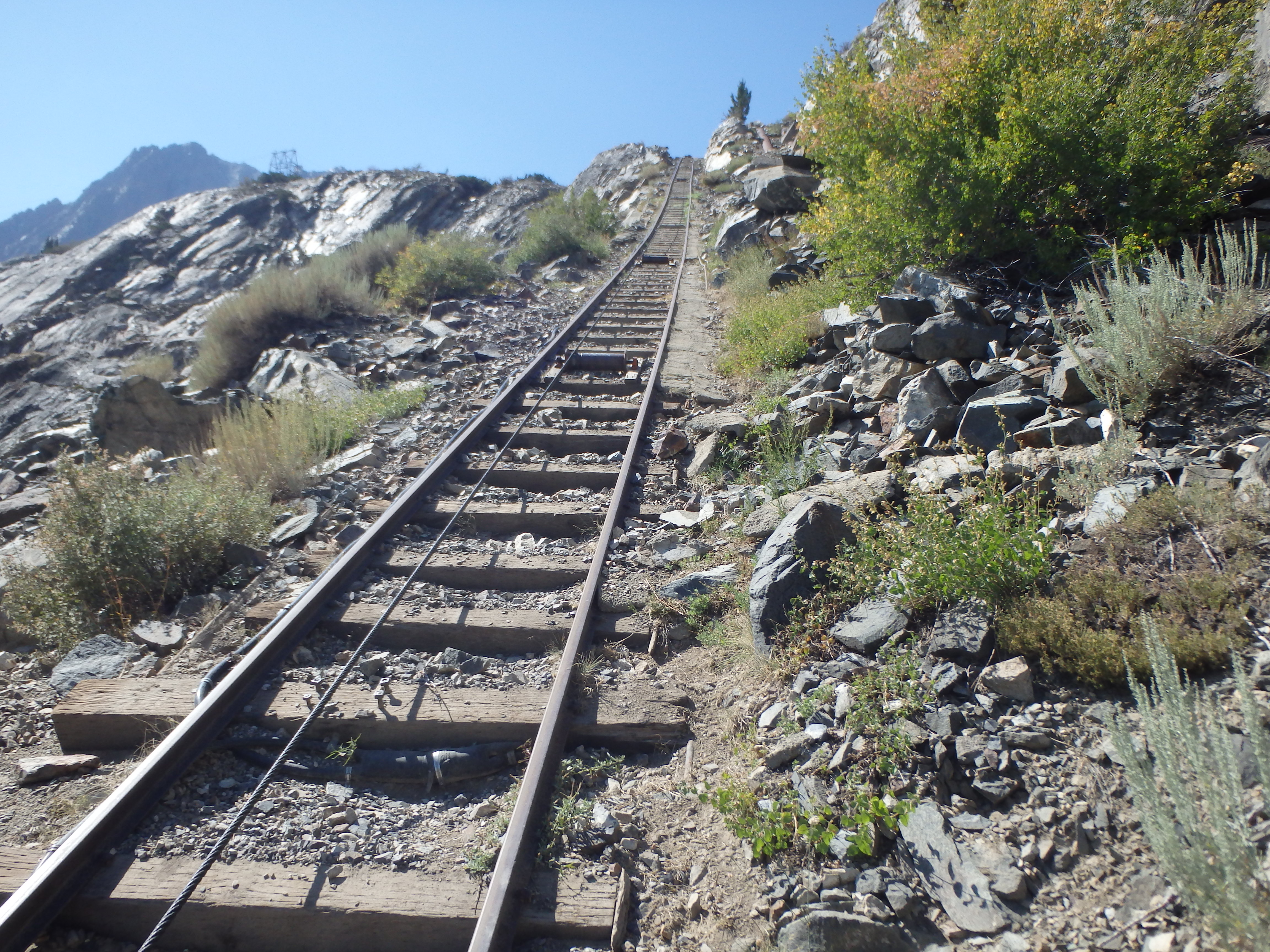
Despite being only a few miles from the car, we were both overheating and needed a break in the shade before continuing on to Agnew. The last few miles were the most painful, completely treeless and exposed, the car coming into view near Silver Lake yet still being almost two miles away. We walked a very short section of the cable car tracks to shave off a switchback or two, then I sped up ahead to the car to get our food out of the bear lockers and refill the waters. I had just finished loading the car when Holly reached the trailhead, and we peeled out of the June Lake area straight for Mammoth Brewery before heading to camp for the night just outside of town.
Hey there. Great trip report. I came across your post looking at Mt Davis. My group and I were there the same weekend you went! Our group was going for Mt Ritter that day you went to Mt Davis. I can actually barely make out our tents (of the two I could make out, one is neon green and the other orange) in one of your pics when you’re almost back to the lake. 🙂
Small world! Need to get back for Ritter, had tried to do it as a double header with Banner but storms chased me off the summit. Just moved back to California so should have a lot more Sierra trip reports coming soon!
Awesome. Welcome back! Hopefully you get that double header soon. I’m looking forward to the inspiration you will provide me. 😀 Also thanks for some of the beta forMfor Davis. I am tentatively planning on going there this September.
For Mt Davis* horrible typo.. Lol