
Crux: Class 2-3


In December of 2013, on my way to an interview in Phoenix, I paid my first visit to Arizona’s Kofa Mountains (short for King of Arizona) in an attempt to climb Signal Peak. My interest in Signal Peak at that time was it’s inclusion on the Sierra Club’s Desert Peak Section (DPS) list, one of eight in Arizona. At that time I had underestimated the climb, attempting it by a nonstandard route via a Northwest canyon that quickly ended in failure. Now an Arizona resident, Signal Peak was a summit I was looking to check off my short list early. Aside from its inclusion on the DPS list, it holds a number of other distinctions. At 4,877′, it stands as the highest mountain in Yuma County. Given it’s challenging routes and the painful drive just getting there, it is widely considered to be the most difficult of the Arizona County Highpoints. With 3,477′ of prominence, it is the 16th most prominent mountain in the state, and one of 73 summits in AZ with greater than 2000′ of prominence. It is also the crown jewel of Kofa National Wildlife Refuge, designated in 1939 to protect desert bighorn sheep, a large number of migrating birds, and the rare Sonoran Pronghorn, reintroduced in 2011. The Kofas are a bit of a drive from civilization, located south of the RV colony of Quartzite, 15 miles from the California border. I left Phoenix at 5AM, looking to get to the trailhead around sunrise. While Kofa takes about 2:30 from Phoenix, I hadn’t anticipated another 45 minutes of driving on 8 miles of rough road to reach Indian Canyon. The 4×4 track started out innocently enough, and even seemed like it had been reworked recently. But the last 2-3 miles after swinging into Kofa Queen Canyon were rough, basically driving directly in a river bed. After about 20 minutes of this, I pulled off into a clearing, realizing that I could walk as fast as I was driving at that point.

I was about a mile from Indian Canyon, and enjoyed the dramatic rock spires and towers in the early morning light. After about 30 minutes I hit the turn off for Indian Canyon, with Ten Ewe Mountain dramatically towering over the headwall.
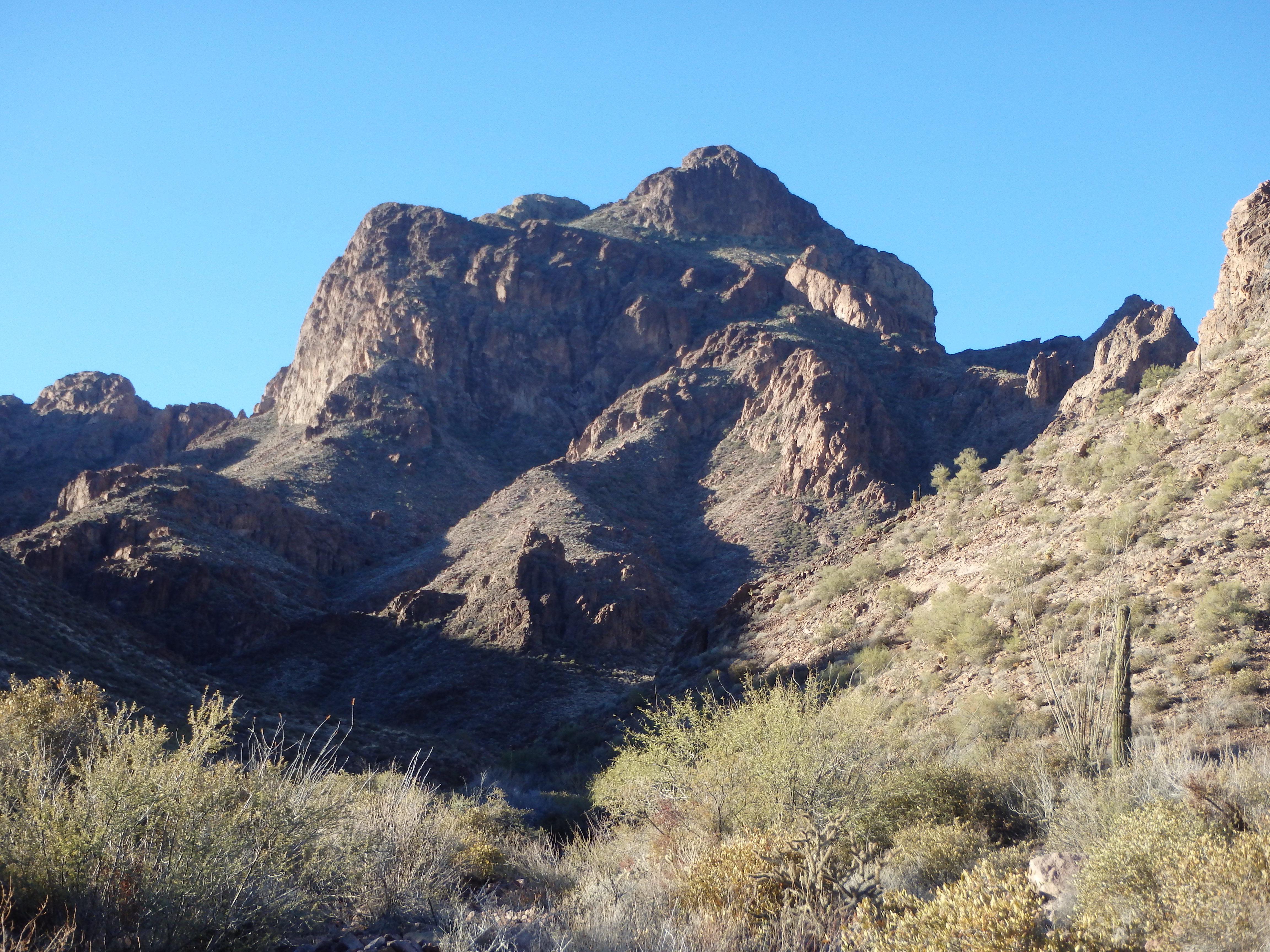
There was a use trail that started from a wide area in the which followed a small wash, eventually meeting up with the larger wash up canyon. As I neared the headwall, the use trail left the wash to climb a shallow ridge which ran beneath the cliffs of Ten Ewe peak, to the left of some dry waterfalls. I reached a flat area and took a short break, having only been in the canyon for 20 minutes, but already having gained significant elevation.

From here, the trail traversed some cliffs below Ten Ewe Peak into a surprisingly lush drainage. I became extremely thankful for the trail, as the climbing in this section would have been miserable, with brush well over my head. The going was a little steeper in this section, and some slabs on the upper slopes brought me to the “half-way notch” I had read about in summitpost. Hitting the notch, I was momentarily disoriented, looking at a drop off before me, thinking I should be looking up at a high plateau. After looking at my map, I could see I was actually still only halfway up the canyon and had merely climbed to a saddle along a side ridge, and was looking across the upper canyon. Reoriented, I continued along the trail, following the drainage directly at times, past some small, frozen pools, filled by recent storms. As I climbed further up canyon, the hiking became more and more enjoyable, eventually hiking directly on smooth slabs in the drainage, free of any brush.

A steep spot near the top of the slabs brought me to a high basin, with the summit finally in view. The feel of the high plateau dramatically changed from brushy, green Sonoran desert, to high Mojave scrub, with scattered Yucca across the plateau.

I continued along the trail, passing some small patches of snow, and topped out on the high summit 10 minutes later. The views from the summit were incredible, looking west across to California, south to the prominent Castle Dome Mountains, north to snow covered summits near Prescott, and west to the spires and summits of the Kofa Mountains. You could even make out Mount Barry Goldwater outside Phoenix in the distance. Although cold, I hunkered down for a long break, reading most of the summit register, which went back about 10 years. It seemed about half the people ascended via Palm Canyon, which I learned after had a class IV variation that bypassed the more technical but ‘classic’ Rusty Bailey route. If I return to Signal, I’d like to climb it via Palm next time.


After signing my name, the cold forced me down, and I followed the trail back to upper Indian Canyon. As I descended the drainage, I turned my attention to Ten Ewe Mountain. On the ascent, it had looked like reaching the summit of Ten Ewe via the saddle shared by the two mountains would be impossible, with 400′ of sheers cliffs blocking any route. But as I descended, I noticed a loose ramp that looked like it wound around to the south, and may provide access to the top.
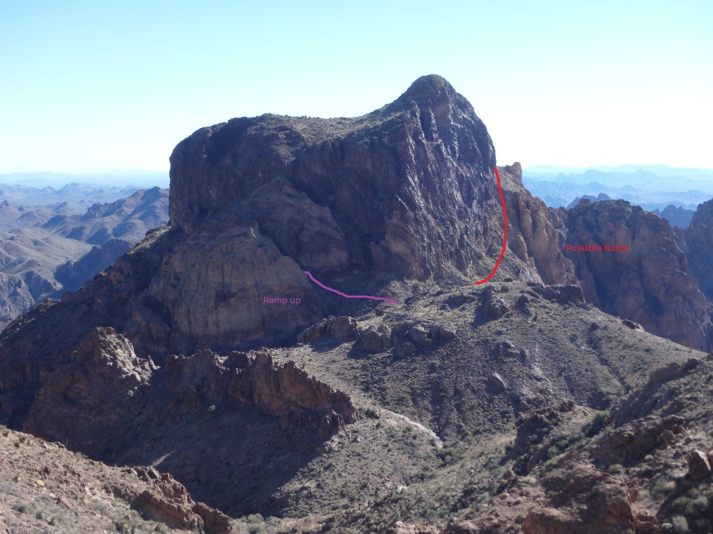
Although I wanted to hike Cunningham in the afternoon, I still had plenty of time, and decided it would be worth checking out. I descended the rock slabs as before, and left the trail to head over a ridge towards the ramp for a closer look. It looked like there was some rockfall in the higher reaches, but if I stuck along the slopes to the left, it would probably work. Just as I was about to hit the saddle, I noticed a different ramp along the north face of the mountain, which had been blocked by an enormous slab from the trail. This looked like it would work even better. I looked through my camera to see if I could tell where it led, and it looked like it would bring me to a series of ledges below the summit.

With no real beta, I headed up the ramp, squeezing through a narrow crack at the top and on to a series of ledges. I followed these as high as I could, finding a class III gully which brought me to the summit plateau. From there, it was a bit more class III to bring me the last 30′ to the top.

There were a few small cairns, suggesting others had been there before me. Overall, I found the climbing was more exciting than on Signal, as I had no idea if the route I was following would end at any time.

I didn’t stay long, still hoping to visit Cunningham in the afternoon, and descended the way I came (my GPS acted a bit funny for this stretch, and the Google Earth track above shows an inaccurate direct path between Signal and Ten Ewe; the descent route is correct). I quickly dropped down the remainder of Indian Canyon and hiked out the stretch of road back to my car, taking about 5.5 hours for the two summits. I slowly headed down the rough road and got back to US-95, setting my sights on Cunningham with the bit of daylight I had left.
Hey Chris. I recently attempted Signal Peak via Palm Canyon and ran into the headwall at Rusty Baillie’s route, which I was previously unaware existed. I didn’t have any climbing gear – I should have done more research before my attempt.
You mention a class IV variant to the summit via palm canyon. Do you have any information on this? A google search isn’t returning anything for me. When I was there I didn’t identify any other potential routes around the rusty baillie route.
https://desertpeaks.org/Cd%20guides/guides/guide0805.pdf
Haven’t looked into it in a while, looks like the class 4 route in the DPS guide goes up a different canyon, it just shares the same TH. There might be something else in Palm Canyon but I researched it a few years ago and I think I pulled that fact off Bob Bird’s trip report.
Hey sorry for the late reply, just saw your comment.
Thanks for the link. I’m going to try to do the rusty baillie route solo next time in the area. Happy hiking!