
Mount Harvard 14,420′ and Mount Columbia 14,073′
Total Time: 13 hours
Roundtrip Mileage: 15.2 miles
Elevation Gain: 7200′
Crux: PD
Trailhead: N. Cottonwood Creek- 2WD, no services


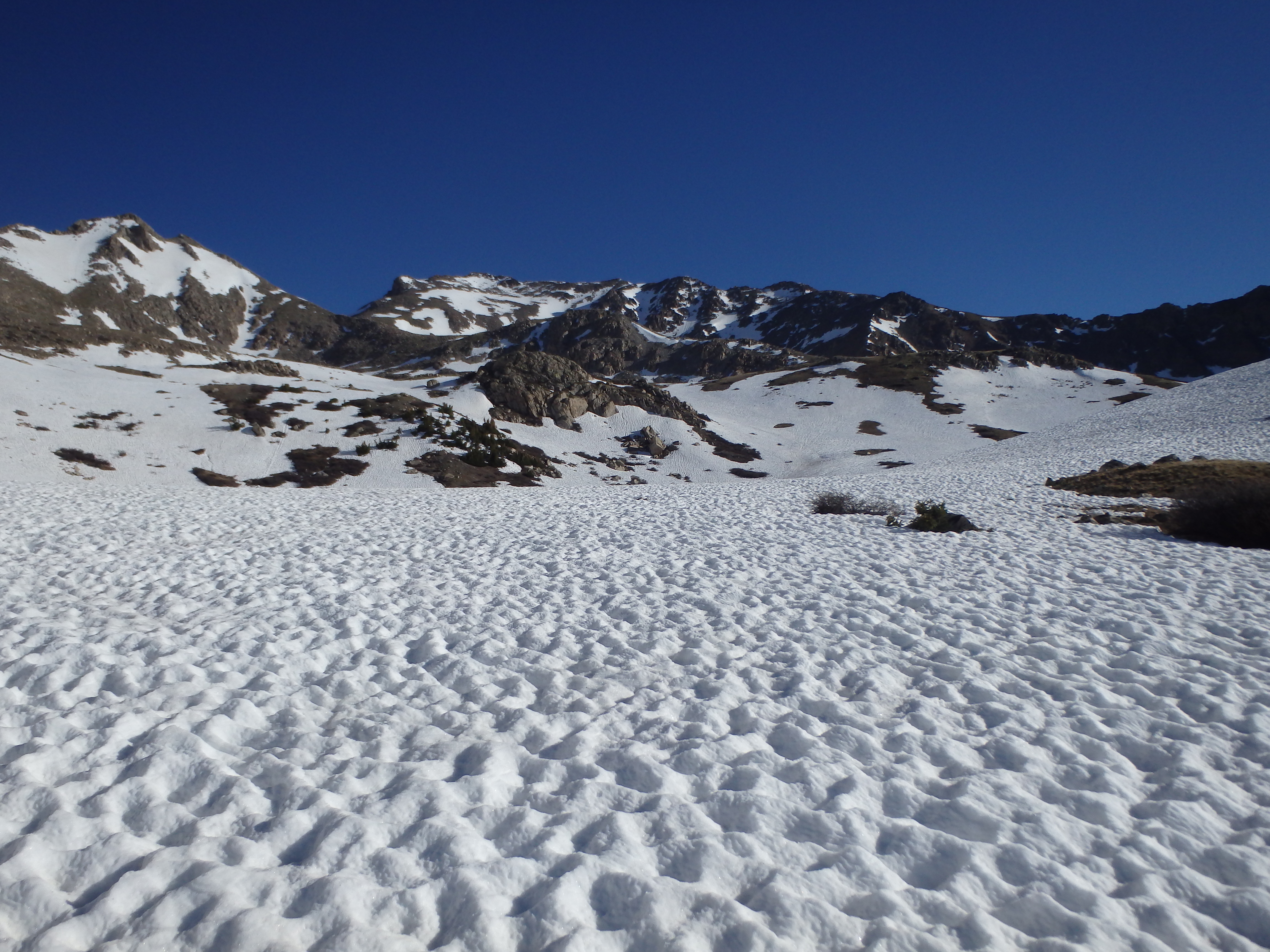
Mount Harvard is the third highest mountain in Colorado and fourth highest in the continental United States, falling only one foot below Colorado’s second highest- Mount Massive. I was interested in Harvard not only for it’s height, but the fact that it could be combined with a traverse Mount Columbia, COs 35th highest peak, allowing for a double 14er day. Having climbed Mount Massive two days prior, I felt equipped to handle the springs conditions in the Sawatch, and thought the combination would make for a reasonable day. I left Denver extremely early, listening to one of several radio stations that would buzz in and out as I worked my way past Fairview and Buena Vista. I arrived at the trailhead at around 5:30AM and had just enough light to not need my headlamp as I started out along the trail. I followed this for about 1.5 miles to a bridge and took a short break, feeling pretty good about the lack of snow so far on the route. Crossing the bridge, the trail began to work a bit more aggressively uphill into Horn Fork Basin, and I started encountering my first patches of snow on the day. By 11,000′, I was in almost 100% snow coverage, but I continued my ascent into the basin, thinking that the snow was lingering in the shade of the pine trees, and might have already melted above treeline. But when I reached treeline, I was a bit surprised to find continuous snow coverage essentially to the summit.

The snow was extremely suncupped and still quite hard, the morning sun not yet rising in the low basin. So without donning crampons, I continued upwards, finding excellent traction on the hard, packed snow. The grade steepened as I reached 12,000′, and I found the buried trail at about 12,600′ as it switched up a rock face into the upper part of the basin directly beneath Harvard’s summit. The trail buried in snow in most spots with large cairns sticking out of the ice, and I put on crampons for the first time all day, wanting the extra grip on the steeper section.


Reaching the upper basin at 13,000′, I opted to continue snowclimbing with an ascending traverse along Harvard’s southern ridge. The upper reaches had received sunlight much longer and the snow was noticeably softer, so I bailed onto the dry, snow free ridge when I had the chance. The weather had been cold but pleasant in the basin, but reaching the exposed ridgeline, I was immediately blasted by wind, even worse than what we had dealt with on Evans several days prior. Working up the ridgeline was particularly exhausting with the wind, being nearly knocked off my feet several times en route. The last 50′ to the summit had some nice solid scrambling with a little extra spice given the ice, but nothing too difficult.


I had hoped the wind might be a little better at the summit, but if anything, was worse. I ducked behind some rocks to take a break, eat some food, and plan my next moves. It had taken me about 4.5 hours to climb Harvard from the trailhead, pretty good time considering the snow I had to deal with. Columbia looked painfully far away, over 3 miles, but I had been mentally prepared for that.


The traverse dips onto the east facing slopes of the connecting ridgeline, so it was difficult to see how much snow I would be dealing with. As I left the relative comfort of the boulders into the wind, I was immediately stymied by some tough ice covered rock that was making keeping true to the ridgeline far too risky. I dropped 20′ onto the north facing slopes and found a series of ledges through the talus that could be used to skirt past several of the false summits along the ridgeline. I ran into a steep snow field along the north slopes and scrambled back up to the ridge, swinging over to the now snow-free south facing slopes to pass the final major obstacle along the ridgeline.

I found the use trail dropping down along the ridgeline, and things temporarily became more pleasant, not encountering snow again until the final pinnacle blocked the descent into the low point of the traverse which had been blocked from view the entire time. I swung wide to avoid some loose steep snow working around grassy slopes and rounded the corner to a discouraging sight- the traverse the remainder of the route was nearly 100% snow coverage, and what should normally be an easy traverse across rocky ledges would be a sketchy traverse across snow that was no longer holding my weight in the early afternoon. I dropped down a bit further into the basin, hoping that the lower angled stuff would hold me a bit better. But I had only gotten 1/3 of the way across the first couloir when I post holed to my hip, and could hear rushing water under my feet. My mind jumped to articles in BP magazine of people falling into spring-time snowcaves caused by undersnow rivers, getting trapped and drowning. Whether I was really in danger of that, I wasn’t willing to find out, and the snow could not hold my weight regardless, with over 1,000′ of postholing to my hip not really being a realistic method.


I got back on to the grass and surveyed my options. Across the basin, there was a grassy rib that had some snow on both sides. But that slope was north facing and the amount of snow I would need to negotiate was minimal. The downside is that it require several hundred additional feet of descent and ascent beyond the standard route, and I was already pretty tired. But I was in a tough spot with my car parked at the trailhead the other side of Columbia- the quickest way back being to summit and drop over. To add an element of danger to the tedium, some large lentiform clouds were forming a few miles away, still looking fairly innocent but changing and building fast enough that they could easily become something more sinister. After some internal debate, I felt like the only reasonable option was to drop completely into the basin and started down, postholing in the flat snow at the base. I took a short break here and started working up the north facing slopes of Columbia. The rock, which looked like loose scree from afar, was actually decent talus, and I made back the lost elevation fairly quickly. The looming clouds were looking progressively darker, and I did my best to pick up the pace at the high altitude, my only reasonable escape up and over Columbia. I was forced to cross snow as I reached the level of a flat shallow bench about halfway up from my low point, and found the snow much more stable, crusted over by the strong winds and receiving less sunlight on the north facing slope.

In fact, the conditions were good enough that I preferentially stuck to the snow and cramponed my way up to the final summit pitch, crossing a section of rock and grass at the base. The last 100′ was very steep snow but it was holding well, and there were faint steps kicked in to add a bit more security. I reached the summit at about 2:30PM just as the clouds I had been racing started to dissipate, allowing me a chance to sit down and take a long break for the first time since Harvard.


Most of the summit rocks were half buried in snow, and I had a hard time trying to stay out of the wind to make the break all that enjoyable, especially with my attention already shifted towards a cold beer and something greasy to eat in Buena Vista. The descent off Columbia was almost entirely on south facing slopes meaning the trail was mostly snow free, and I took off my crampons and started down. Unfortunately, I took a wrong turn down a use trail that wound up taking me down a series of steep, loose chutes. While this was fine on the upper slopes where I could plunge step through sand, lower down became packed dirt with loose scree over the top, and I had to move much more cautiously. The tedium of the thin layer of loose rock over packed dirt continued basically all the way until treeline at about 11,500′ when I reentered continuous snow coverage. I set off through the forest over snow drifts in the general direction of the trail, the snow now soft with constant post-holing as I descended. It took another 30 minutes to come across my footprints in the snow and get back on track. The firm suncups from the morning were long gone having turned to mush, and I tromped and post-holed all the way back to the bridge where I took my first break of the day, over 12 hours before. Even though I was under two miles from the trailhead, I needed one last break before finishing what had turned into a near epic, ultimately hitting the trailhead 13 hours after starting out. I peeled off my wet clothes and put them in the dashboard to try and dry for the next day, then drove back to Buena Vista for pizza, beer and an early bedtime before my final day in Colorado, another double header on Shavano and Tabegauche.