
Hualapai Peak 8417′
Total Time: 5:00
Distance: 10.2
Elevation Gain: 3050′
Crux: Class 3
Trailhead: Mountain Park CG, full services


Hualapai Peak was the Grand Finale of my P2K weekend in northwestern AZ. Not only was it the tallest, it was also the most interesting geographically, with pockets of granite and an impressive class 3 summit rock scramble. Leaving the rough dirt road from Mount Perkins, I headed south into Kingman and onto I-40 before exiting south several miles from town and winding up the paved road to Hualapai Mountain Park. This was the only paved trailhead for the weekend, and I parked my car in the half full lot. Right from the start I was impressed, with enough elevation to already be in tall pines with some small pockets of aspen up high.


Directly ahead of me was the rocky summit of Aspen Peak, blocking a direct route to the summit of Hualapai. A popular hike, the Potato Patch Loop, loops around Aspen Peak, and I took a turn onto the eastern limb of the loop towards Hualapai Peak. The trail switched underneath some rather impressive rock faces, and I couldn’t help but think the area was prime for some multipitch climbing, although I couldn’t spot any bolts or signs of climbing activity on the rock face above.


The views began to open up to the east with the pines a bit thinner in the rocky sections. As the trail rounded the shoulder of Aspen Peak, Hualapai popped into view just as I passed a thunder shelter for those caught in the summer monsoons. It was thankfully too early for monsoon season, and this close to the trailhead, I’d probably just make a break for it if caught in a storm.


From there, I dropped down hill into the “Potato Patch,” a valley between Hualapai and Aspen that once held a potato farm before the small range became a park. I hit a larged signed Hualapai Trail junction with an old road and turned left, descending even further into the valley.


The trail dropped so much that I thought I might be heading in the wrong direction, but a helicopter landing area indicated on the park map assured me on was on the right track. The trail finally started to climb steeply towards the summit, wasting little time with switchbacks and heading directly upslope. The old road here was much more overgrown with deep ruts and several fallen trees, clearly not having seen vehicles in some time. A few hundred feet below the summit, the trail entered an open valley with the summit rocks straight ahead. I passed a pair of hikers below the final set of switchbacks and motored up to the lookout just below the summit rocks.


There was a cairn marking the class 2-3 use trail up the north side of the cliff, but I was more interested in one of the various exposed class 3 lines on the east and south faces. I spotted a line on the east face that looked like it would go, but turned back about 20′ up after stopping at a very exposed mantle move that would be easy but a little too risky.


I downclimbed and tried one crack system further south. Aside from working through a small amount of brush, the line was excellent and clean, and put me just below the large boulder at the summit. The benchmark was on a lower rock, and it took a somewhat exposed move to reach the highest point. The beautiful hike through the pines coupled with the excellent class 3 made this the best hike for the weekend, and probably one of my favorites in Arizona so far. The two hikers I had passed scrambled up a different route from the south side and we chatted for a bit, one of them working out of his car in the Mojave Desert monitoring raven activity for when they prey on the endangered desert tortoise.


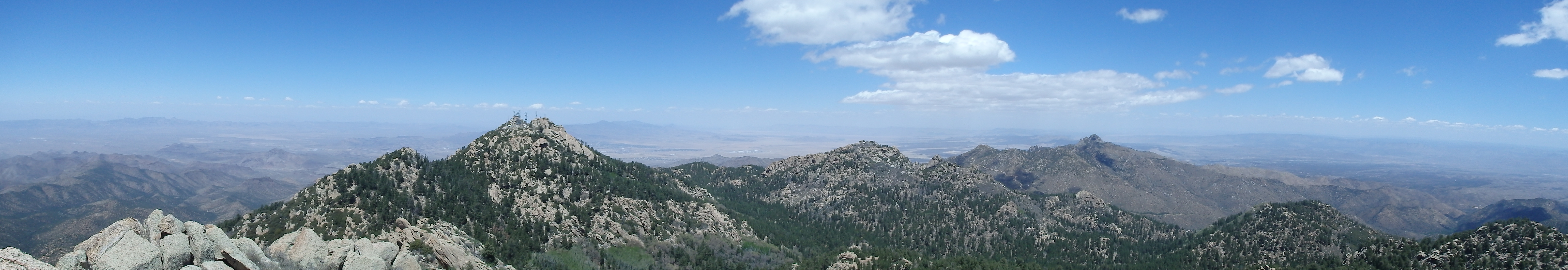
I eyed Mount Hayden and Aspen Peak across the valley, which would have made for a couple easy bonus peaks on the day. But I had made a promise to make it back to Phoenix for a friend’s birthday dinner, and as I scrambled back down, it looked like I probably wouldn’t have time for either. Instead, I opted to take the other half of the loop around Aspen Peak, hooking to the west through a pretty nice back country campground, surprisingly empty for the weekend. This area also seemed to have some good opportunities for rock climbing, with plenty of small walls and short spires making a nice backdrop for the grounds.


The trail headed uphill as it wound around Aspen Peak before beginning the descent back to the parking lot. I briefly lost the trail when I wasn’t paying attention, but found it after backtracking, missing a very obvious switchback. I hit my car at about 2PM, which would give me just enough time to make it back to Phoenix and shower before meeting my friend for dinner. I drove out back towards I-40, taking one final shot of the best summit of the weekend before getting on the interstate for the drive home.
